History
The construction of the city defensive walls of Tallinn (German: Reval) began in 1265, during the reign of Margaret Sambiria, daughter of the Pomeranian prince Sambor II and queen of Denmark, who received Livonia for life. In that year, the queen sent a letter to the vassals staying in Tallinn to secure the city with ramparts and a wall, but already earlier, probably since obtaining Lübeck charter in 1248, Tallinn was protected by wood and earth fortifications. The costs of building the walls were to be covered by court fines, and from 1280 by royal revenues from rents, inns and the city mint. Moreover, monasteries that were adjacent to the city fortifications were to participate in the construction works. As the construction of fortifications was expensive and time-consuming, it were probably not completed during Margaret’s rule. At the end of the 13th century, outside the fortified area of the city were a Rus and Scandinavian merchant settlements and a Cistercian nunnery dedicated to St. Michael (however, it had its own fortifications).
In 1310, the Danish governor Johannes Cannes initiated further construction works, which were continued in the 1340s, when the southern, south-eastern and northern parts of Tallinn, originally occupied by scattered buildings and unfortified settlements, were included within the stone walls. Within the city fortifications there was also a Cistercian nunnery, the walls of which on the western and northern sections were added to the new line of city fortifications. Construction works continued as the city’s population and wealth grew, while the requirements for defensive structures changed due to the development of siege art. It is not known at what stage the works were in 1343 when the Aesti uprising broke out, but it must have been advanced because two years later, in 1345, the townspeople received from the Danish King Valdemar IV the right to direct the waters of Lake Ülemiste to the southern and eastern moats and permission for the construction of water mills there. A year later, the Danes sold the area of northern Livonia to the Teutonic Knights, and the construction of the fortifications was completed under the new feudal authority. The full defensive perimeter of Tallinn was closed around 1355, when docuemnts recorded a tower near the baths under the hill (“turris iuxta stupam sub longo monte”) and the Nuns’ Gate (“Porta Monialium”). The city book also recorded eleven people responsible for the defense of individual towers.
In the third quarter of the 14th century, work on the fortifications was focused on two sections considered most at risk and in places where it was decided to correct the course of the fortifications and slightly enlarge the city. In the north-western part, it was agreed with the Cistercian nuns from the neighboring nunnery to correct the course of the fortifications, to which numerous new towers were added, including those in the form of bartizans, very popular in Tallinn. Some of the new north-west towers were founded by the then mayors, Winant Louenschede or Herman Lippe, while the towers in the south-west corner of the city may have been built under the influence of architectural traditions from the heavily fortified town of Visby, from which refugees settled in Tallinn after the invasion of the Danish king Valdemar IV in 1361. When the next stage of expanding Tallinn’s fortifications was completed in 1373, a list of commanders responsible for the defense of specific towers was created again, and this time there were fifteen of them (two commanders were assigned to each). It was also mentioned that the garrison would be armed with crossbows and the towers with throwing machines (the larger ones were to have two, the smaller ones one machine). As many as three machines were handed over to the Viru Gate, considered the most important in the city. In 1380, Wilhelm von Freimersheim, the Land Master of the Teutonic Knights, gave consent to rebuild the wooden city gate under the castle into a stone one, with the disclaimer that it could be destroyed in the future at the request of the order.
In the 15th century, Tallinn’s fortifications were successively expanded and strengthened, as a result of which the city was one of the best fortified on the Baltic Sea in the Middle Ages. By 1413, when another list was created, containing the names of 27 defensive works and the names of the crew commanders responsible for them, several new towers were built, including one named after the commander Herbord Plate, and another after Wulfard Rosendal, mayor of Turku, who lived near the tower. Other towers were also named after the owners of nearby plots or residents, such as Asso, Stolting, or Hinko. Some of towers may have burned down in 1433, during the great fire that raged in Tallinn. The wooden elements of the walls and towers (ceilings, roofs, porches, doors), as well as the weapons, were destroyed. A little earlier, the fortifications on part of the north-western section of the perimeter were the subject of a dispute with the Cistercian nunnery, which ultimately led in 1422 to the city authorities’ intrusion and the demolition of the bathhouse and barn adjacent to the defensive wall, which reduced the city’s defenses. Ultimately, the Teutonic arbitration court ordered the city council to rebuild the destroyed buildings, but in a different place, and the Cistercian nuns were to separate their estates from the fortifications with a new wall. Thanks to this, the city now became the owner of the entire ring of the wall and could start strengthening the fortifications also in the monastery area.
According to records from 1430, the construction of a new moat in front of the Coastal Gate was to be completed, and in 1442 moat was modernized in front of the Nuns’, Viru and Sand gates. Then, in the years 1448-1452, the foregate of the Harju Gate was built, in the years 1453-1454 the foregate of the Sand Gate, in 1454 the Viru Gate, two years later the foregate of the Cattle Gate and in 1461 the Nuns’ Gate. Moreover, during this period, the outer wall of the zwinger was built on two sections of the fortification perimeter. These changes were primarily a reaction to the progressive development of firearms and an attempt to secure the most sensitive places of the fortifications, which were the entrances to the city. Interestingly, despite the considerable strength of Tallinn’s fortifications, it was only in the years 1454-1455 that the section of fortifications between the city and the castle was rebuilt into a stone one, so far made only of wood and earth.
The last stage of the expansion of the city fortifications began in the fourth quarter of the 15th century, when the towers and curtains were raised. In 1479, a new tower was recorded at the Harju Gate, opposite the horse drinking trough (Kiek in de Kök), which was probably also recorded in 1475. At the turn of the 15th and 16th centuries, it was thoroughly rebuilt in order to protect the most endangered part of the city’s fortifications with cannons, becoming one of the most impressive cannon towers in the region. In 1513, a new list of Tallinn’s defensive works was created, which documented 30 towers from various periods of construction. Several towers were omitted for unknown reasons, because they were probably undergoing reconstruction at that time and could not have had a garrison. In addition to late medieval modernization works, the replacement of weapons was also completed at the turn of the 15th and 16th centuries. The obsolete baroballistic machines were eventually replaced with firearms. The culmination of the late medieval expansion of Tallinn’s fortifications was the construction of the massive Fat Margaret Bastion, probably built under the supervision of the master builder Gert Koningek. It was completed around 1529-1531, although mentions of minor construction works at the gate were recorded until the mid-16th century.
In 1558, the Livonian War broke out, which initiated accelerated preparations for defense in Tallinn, focused mainly on demolishing buildings illegally erected near the fortifications, as well as in the foreground of the city. Each resident was told to demolish or burn his or her garden, house, shed, bathhouse, or any utility structure that could impede defense or provide shelter for attackers. Work was also carried out on the front earthen line of the ramparts, reinforced with hastily constructed fortifications. When the state of the Teutonic Knights fell, the city came under Swedish rule in 1561. In 1569, the Danish and Lübeck fleets bombarded the city, but the guns placed in the Coastal Gate complex contributed to effective defense. In 1577, Tallinn managed to withstand the siege of the Moscow army, during which some parts of the fortifications were damaged (e.g. the Kiek in de Kök Tower). The fortifications were modernized after the end of the war in 1582, but the works from the end of the 16th century were limited in scope and did not change the late medieval form of the walls.
In the 17th century, despite plans to introduce the early modern bastion defense system on a larger scale, Tallinn’s older walls continued to function. More serious changes were held back by the economic crisis, which even led to a lack of repairs and neglect of the defensive buildings. Only after 1650, when the economic situation began to improve due to the revival of grain export, several bastions were built in front of the old fortification line. The old medieval defensive walls finally lost its importance and were gradually absorbed by the expanding early modern residential buildings. Some of the towers were adapted for new roles, mainly for storage and residential purposes, but many of them fell into ruin. The medieval city walls did not play a major role during the siege of the city by the Russians in 1710, and the fall of Tallinn was not stopped by early modern bastion fortifications. As in other cities, the slightening of medieval fortifications began at the end of the 18th century and continued until the second half of the 19th century. The youngest tower, Luerborch, was demolished first in 1767, followed by the Sand Gate in 1779. Many towers were demolished after 1857, when the walls were officially handed over to the city authorities. The process of destruction stopped only at the end of the 19th century, with the increasing awareness of the historical importance of Tallinn’s walls.
Architecture
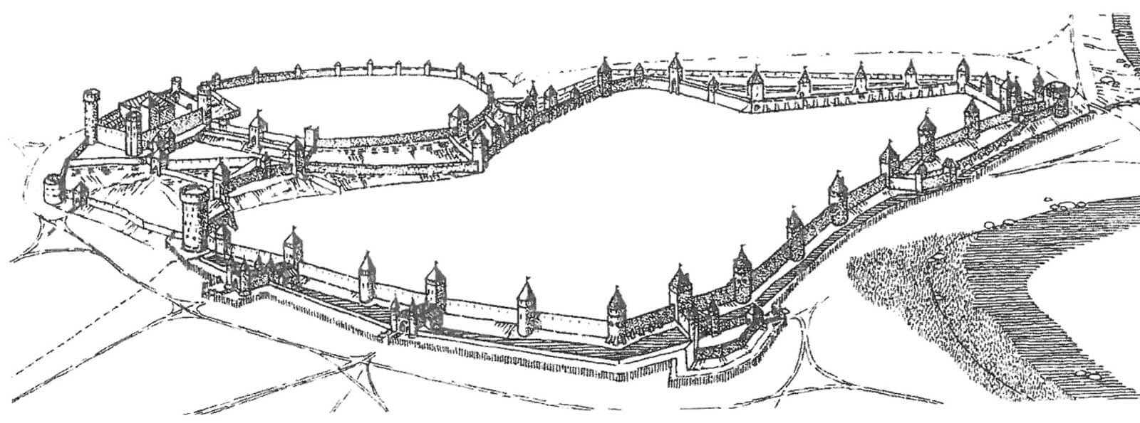
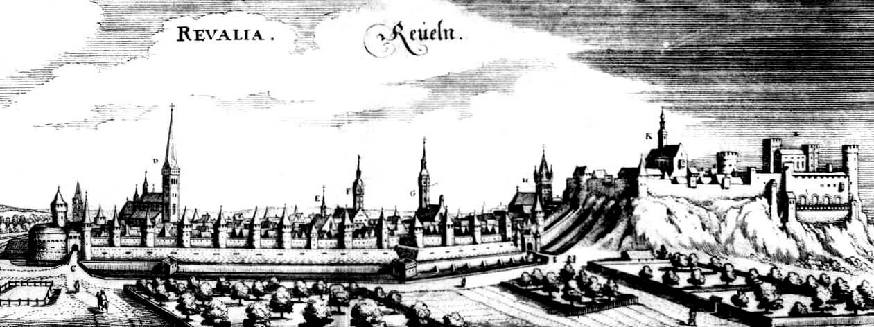
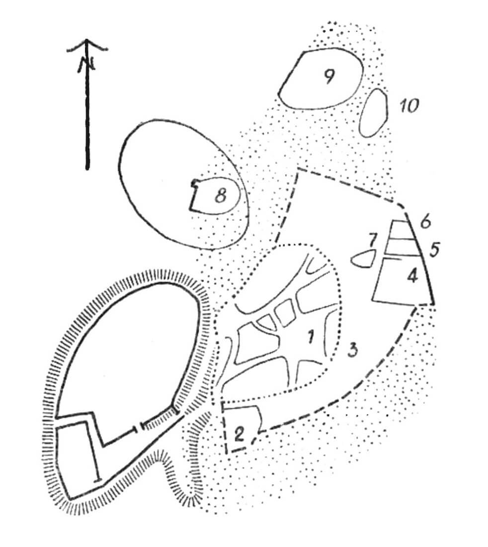
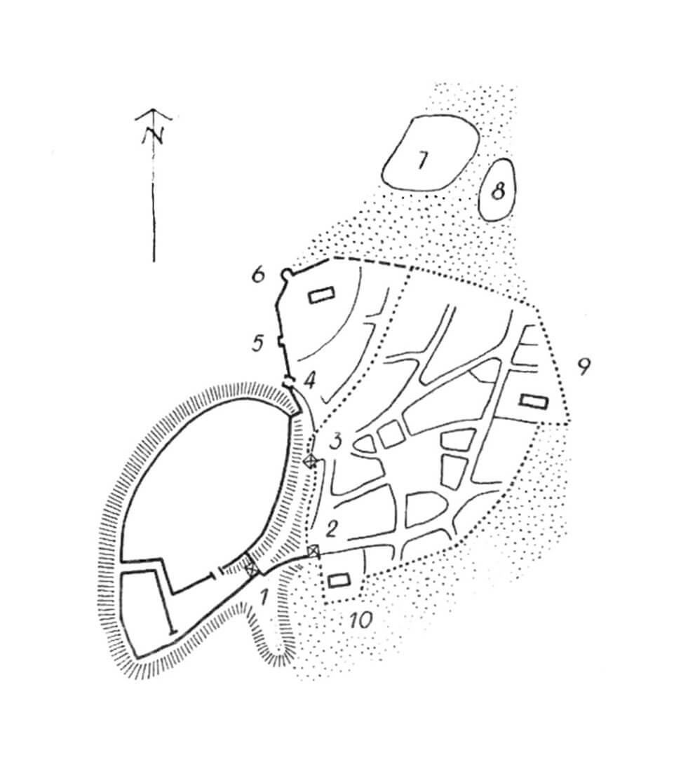
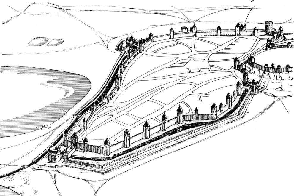
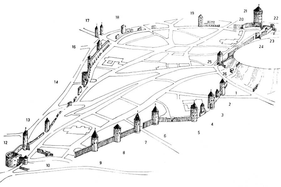
In the late Middle Ages, Tallinn had an irregular shape, elongated north-south, with numerous curves and corners. This was due to the fact that the lines of the fortifications were adapted to the form of the terrain, as well as the shape of the original settlement and smaller population centers adjacent to it, as well as the phased expansion associated with the inclusion of new areas to the fortified part of the city. From the west and south-west, the city was adjacent to the castle hill. On the northern side, the terrain was low, but at the same time swampy. The area on the south-eastern side was similarly swampy, while in the east, not far from the city, there was the shore of the bay. The plain foreground remained only in the north-west and south, but there the significant terrain obstacles were artificially created ponds and canals where mills operated.
The oldest fortifications from the second half of the 13th century surrounded the city core, which was similar in plan to a triangle, on the eastern side of the castle hill. Around the middle of the 14th century, the ring of defensive walls was extended in the south and south-east, so that the farthest part of the city was in line with the castle, occupying the southern tip of the hill. In addition, the defensive wall was extended on the northern side, where the settlement of Scandinavian merchants with the church of St. Olaf and the neighboring settlement of Rus merchants were incorporated into the fortified area. The expansion of the city also involved a new irrigated moat on the southern and eastern sections, and therefore with the carrying out of major earthworks, the lowering the ground level along the line of the ditch by up to 10 meters (the earth extracted from the moat became a backfill layer along the line of the erected walls). The last major correction of the fortification line was a slight enlargement of the city area in the third quarter of the 14th century on the northern side of the Cistercian nunnery and on the southwestern side, at the foot of the castle hill. In the final shape, the fortifications were approximately 1,500 meters long.
The oldest city walls from the second half of the 13th century were built of limestone joined with weak mortar. It were about 4.5-5 meters high and varied in thickness from about 1.1 meter to 1.3 meters at the base. The sections erected from the first quarter of the 14th century were approximately 6 meters high and 1.3-1.6 meters thick. The 14th-century walls were built on an earth embankment 0.5 to 1.1 meters thick, which in some places was even slightly higher, because a limestone foundation covered with sand, about 0.9 meters high, was also buried in the embankment. Only in sections where the plateau was slightly higher (e.g. on the eastern side of the city, near the Dominican friary), the thickness of the earth layer under the wall was only 25-30 cm. From the city side, the embankment could reach a distance of at least 3.5-5 meters, while in front of the outer side of the wall there was a slope reaching directly to the moat. It was approximately 2.5-3 meters high, but the slope was even greater in areas where the overall slope of the original terrain was greater or where the walls were built on natural hills.
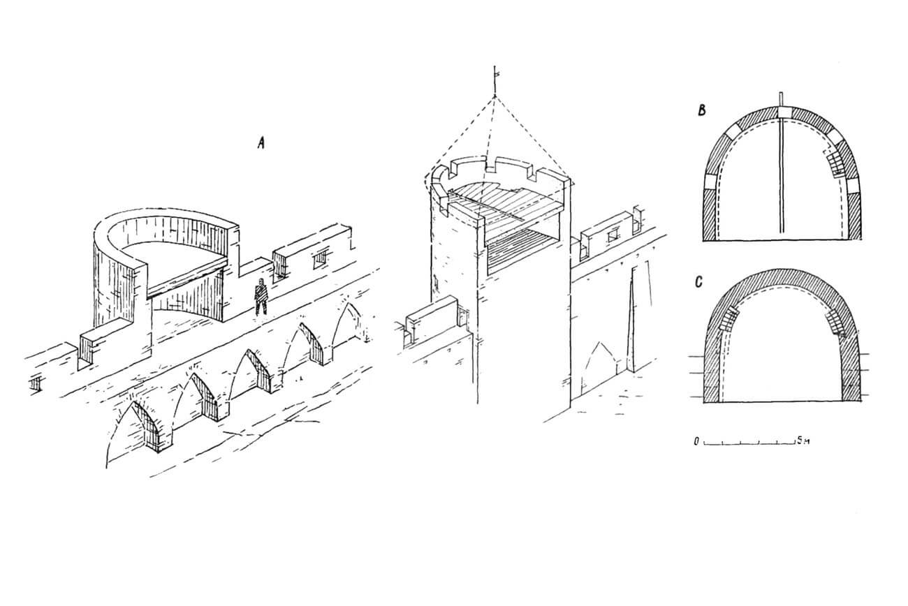
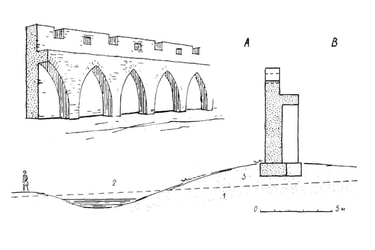
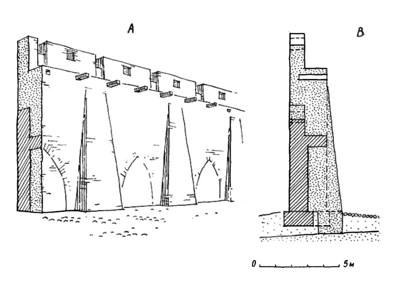
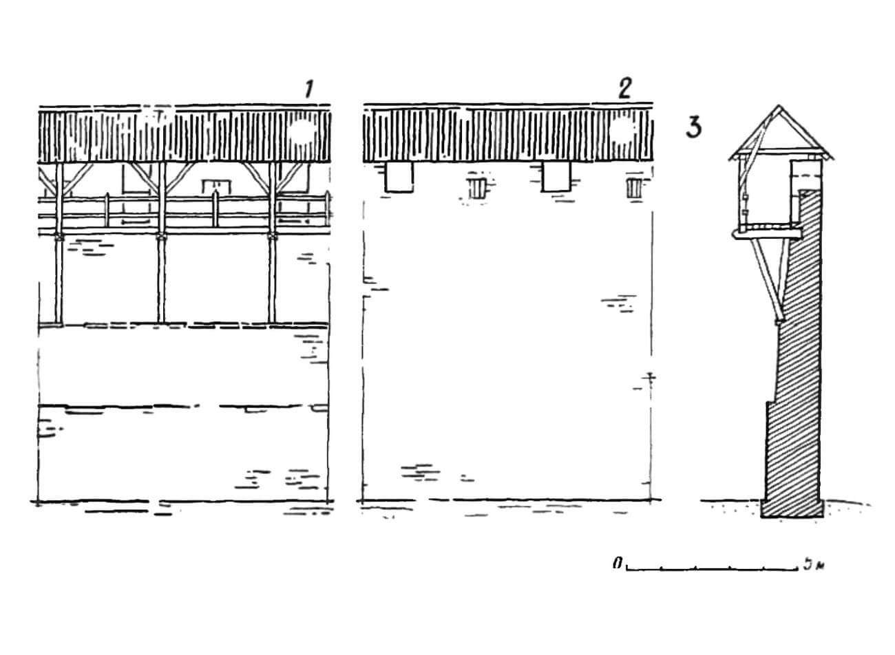
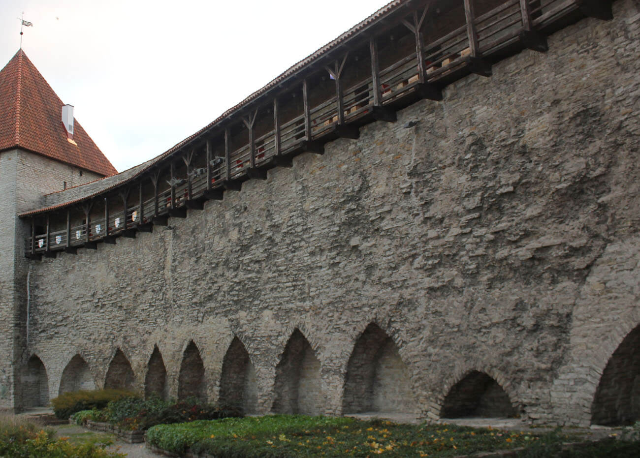
The defenders initially moved along the fortifications on a wooden porch attached to the inner façade of the wall on poles reaching to the ground. The curtains originally lacked loopholes, and only the breastworks were used for defense. Around the mid-14th century, the first innovation was the battlement with embrasures, in which merlons with loopholes alternated with sections of parapet without merlons. The former were used for observation and crossbow shooting, the latter were mainly used for active combat. Behind the parapet there was a wall-walk, no longer placed on a wooden porch, but supported by ogival arcades. Interestingly, these arcades, which constitute a significant thickening of the wall, were not made on the axis of the loopholes, but with various shifts, thanks to which it was impossible to guess the weakest parts of the wall from the outside. Its purpose was not only to thicken the walls, but also to save building materials and speed up the construction process. The total thickness of the defensive wall was then 2.3-2.6 meters, and the height was about 6.5 meters, without the height of the earth embankment and the slope of the land lowering towards the moat. Despite many stages of expansion, Tallinn’s defensive walls in the 14th century were relatively uniform, which distinguished them from the gradually introduced system of towers.
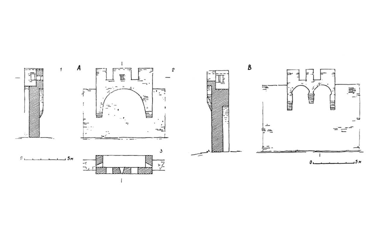
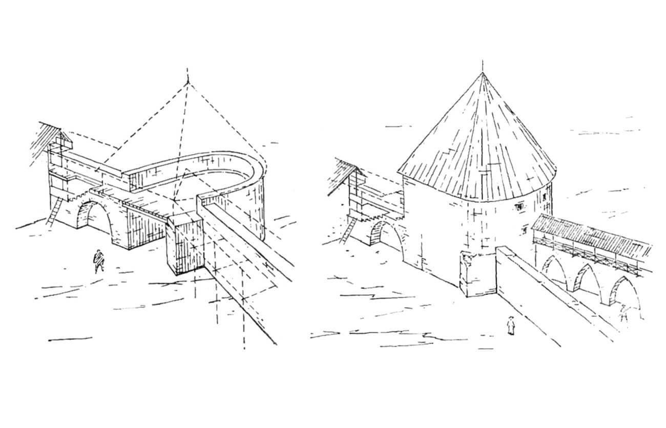
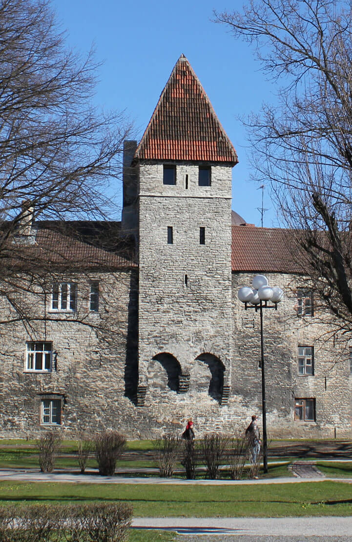
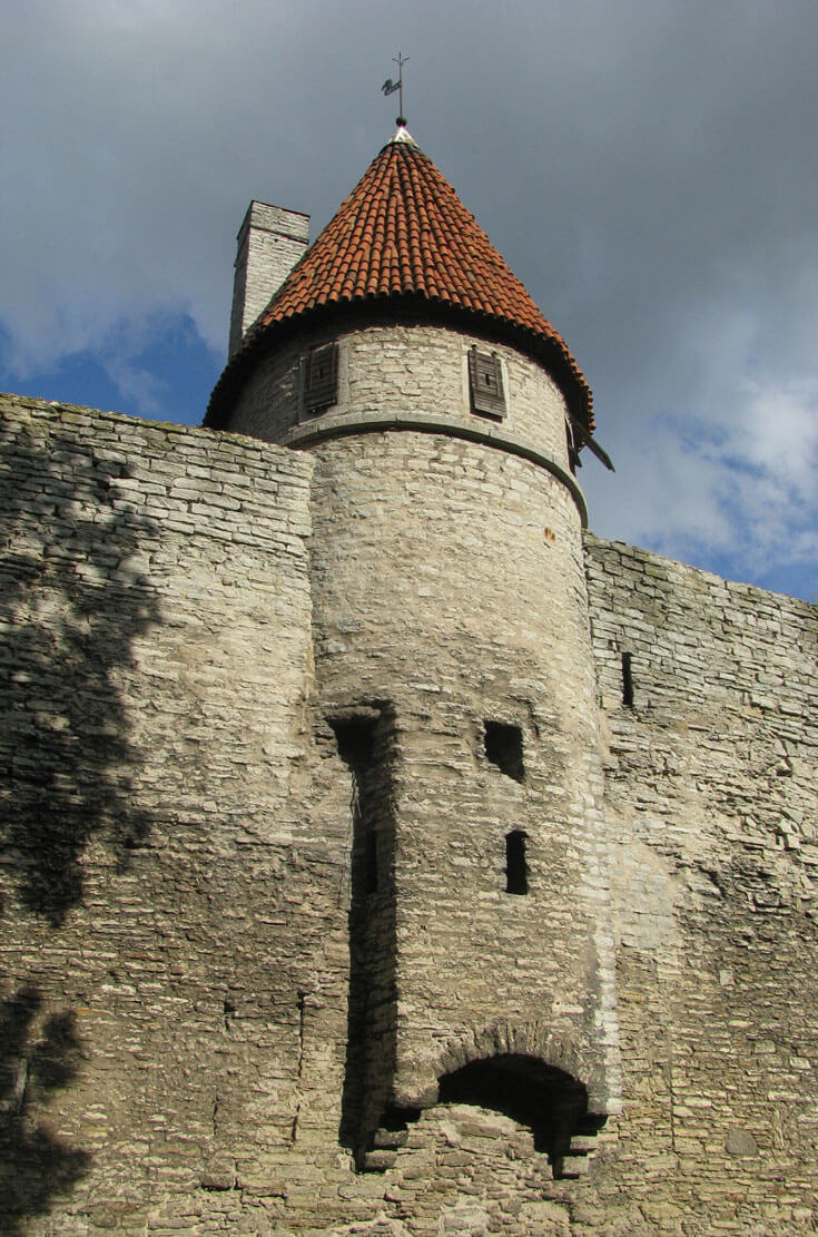
In the section of fortifications adjacent to the Cistercian nunnery, in order to improve the defensive properties in the north-western part of the city, a rectangular bartizan called the Nuns’ Tower (Nunnatorn) was built on the wall in the first half of the 14th century. It was suspended on stepped corbels and a semicircular, wide arcade. It was opened from the city side, accessible from the wall-walk, and protruded only 0.4 meters in front of the neighboring curtains. It reached approximately 8.4 meters in height above the level of the original ground. In the battlemented parapet the bartizan had two side rectangular loopholes and one on the front, all splayed to the interior.
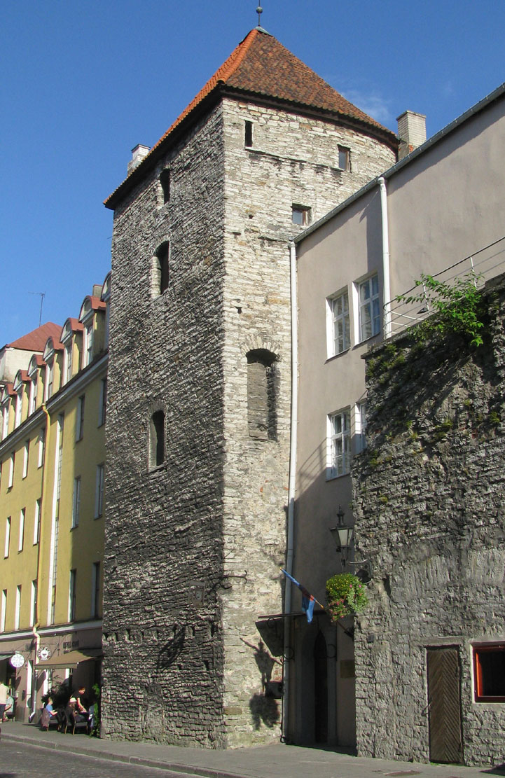
The second oldest defensive work in the wall line at the Cistercian nunnery was the corner tower called the Golden Leg (Kuldjala), built on a horseshoe plan, 9 meters wide, 7 meters high and 1.7 meters thick. It was strongly protruded in front of the two adjacent curtains and opened from the inside. Initially, it had only two floors: a 5-meter-high ground floor covered with a wooden ceiling and a fighting level at the height of the wall-walk. The latter, on the northern side, was wooden, like the rest of the perimeter, but in the south it was set on a stone semicircular arcade, which was probably topped with stairs on one side. The arcade also provided a passage to the neighboring Cistercian nuns’ building, presumably a bath house. The protection of the defenders on the first floor of the tower was provided by a simple breastwork without loopholes. The stone part of the tower, as well as the adjacent city wall, may have had a wooden superstructure or roof, often used in medieval defensive structures.
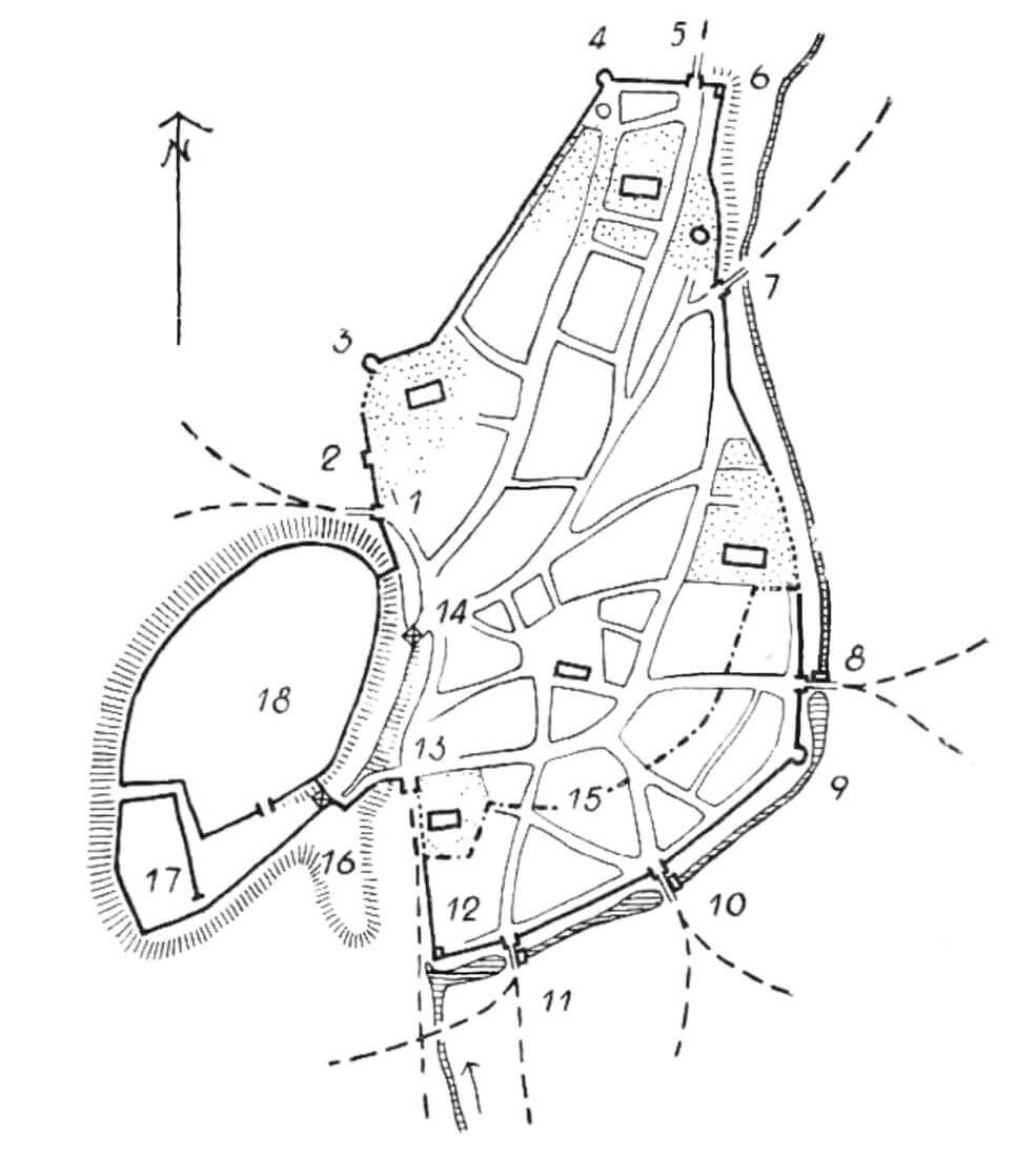
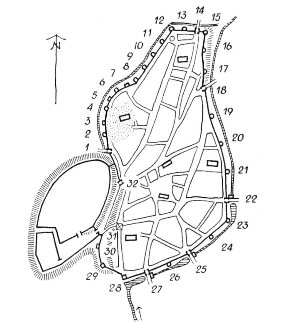
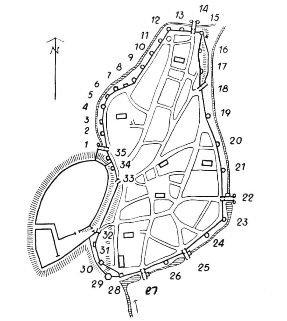
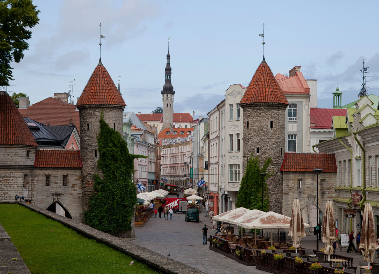
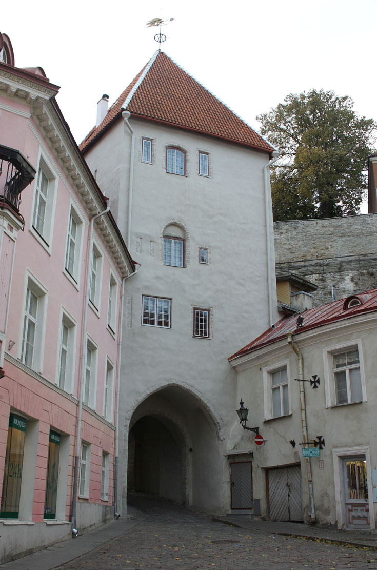
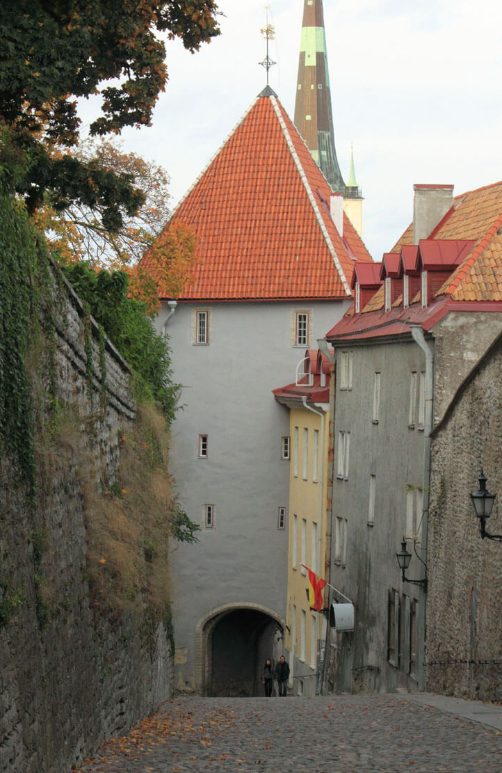
In the mid-14th century, entry to the city was through eight gates, usually located in four-sided towers with passages on the ground floor. In the western part of the city, right at the base of the castle hill, there was the Nuns’ Gate (Nunnaväravat), located on the southern side of the Cistercian nunnery. In the short northern section there was the Coastal or Sea Gate (Suur Rannavärav), originally called Strantporte, leading from the city to the port. On the north-eastern side there was the Sand Gate (Väike Rannavärav), facing the beach, where, among other things, there were boat launching ramps, while on the south-eastern side there was the Viru Gate, originally called Lehmporte, named after the old Baltic settlement towards which it was directed. In the southern part of the city, two gates were created: the Cattle Gate (Karjavärav) leading to the suburban pastures and the Harju Gate, named after the nearby settlement, but also called Smiths’ Gate, originally Smedeporte, after the craftsmen who dominated the street leading to it. Both southern gates were connected to water mills built outside the city over the moat, which in places had the form of pond cut by dikes leading to the gates. The last gates were on the western side, from where the road led along the slope towards the cathedral and the castle. The northern one was unusually called Long Hill (Pika Mäe), because it was connected to a longer route to the castle than the Short Hill Gate (Lühikese Mäe) located on its southern side. Both gates were wooden structures for a long time, because the city was defended from this side by a castle. Only after 1380 was the stone Long Leg Gate (Pika Jala) built.
The section of the north-west wall was equipped with a corner Rent Tower (Rentenitorn) before the mid-14th century. A dozen or so years later, the Epping and Ropemakers’ (Köismäe) towers were added to the south of it, both built on a semicircular or horseshoe plan. These towers were closed with walls from the city side. It had at least three floors, the upper two of which had defensive functions and were equipped with new-type loopholes. The ground floor could be used to store war materials. From the south, another structure was the Lippe Tower in the form of a rectangular bartizan and the Loewenschede Tower. Between the semicircular Loewenschede Tower and the Golden Leg Tower, a rectangular bartizan called Behind the Nuns’ (Nunnadetagune) was built, and south of the Golden Leg the Bath Tower bartizan (Saunatorn), probably named after the bath or sauna at the Cistercian nunnery. From the south, it was adjacent to the older bartizan of the Nuns (Nunnatorn).
In the third quarter of the 14th century, the north-western part of the fortifications had to be considered the most difficult to defend, due to the flat terrain there, devoid of major natural obstacles. The fragment of the fortifications located next to the Cistercian nunnery was then decided to rebuild and slightly enlarge the city area, including the buildings of a small settlement situated on a hill, where mainly Estonian ropemakers lived. After the reconstruction, the north-western part of the perimeter became the most heavily fortified part of the city with the largest number of regularly placed towers. The corner at the Golden Leg Tower (Kuldjala) was also reduced, as a new curtain was placed from the north, and then the new fragment of the fortifications was rounded more delicately. Moreover, a moat was created along the entire north-west and north sections.
The bartisans in the north-western section of the fortifications were similar to each other, built on a rectangular plan, slightly protruding in front of the face of the defensive wall. Behind the Nuns’ Tower was 5.7 meters wide and about 10 meters high from the original ground level. On the outer side it was supported by two semicircular arcades based on stepped consoles. From the front there were only two arrowslit in the Behind the Nuns’ and Nuns’ bartizans, while the Bath Tower bartizan also had a loophole in the side wall. The latter was opened on the city side, but its side walls reached into the ground, thus creating a kind of base on which there was a defensive platform. Later, when the tower was raised, a semicircular arcade was supported on the cornices of the former defensive storey, mistakenly believed to be the bricked-up gate of the nearby Cistercian nunnery.
During the reconstruction from the third quarter of the 14th century, the older Golden Leg Tower (Kuldjala) was not removed, but it was modernized in accordance with the type introduced during the construction of the Ropemakers’ and Epping towers. It was raised to three storeys and closed with a wall on the side of the street under the wall. However, the new floors were very low, because apparently the city was not interested in incurring large expenses for the nunnery, which was formally responsible for taking care of this section of the fortifications. Both floors were equipped with closely spaced loopholes, two of which were directed towards the strip of land north of the tower, in the place created between the old and new defensive walls. Since the wall connected to the tower from the south was to remain in the possession of the nunnery, only one entrance was made in the monastery courtyard, near the former stairs. From there, above the arcade of the defensive wall, another stairs on consoles led to the new floor of the tower.
The southwestern part of the city covered the elevated area in front of the church of St. Nicholas, after being enlarged in the third quarter of the 14th century. It was occupied by stables and municipal workshops, from which the area was called Marstallberg. The arch-shaped defensive wall was reinforced in the new section with three towers: Stable Tower (Tallitorn), Virgin Tower (Neitsitorn) and Goat Tower (Zeghenitorn). The southernmost and adjacent to the old section of the defensive wall, the Goat Tower, was built on a quadrilateral plan, the Virgin’s Tower had a similar form, while the Stable Tower, adjacent to the gate leading to the castle, had the form of a rounded bartizan of small size. The four-sided towers were already a bit outdated at that time, architecturally closest to the city walls of Visby, which were built much earlier, in the 13th century.
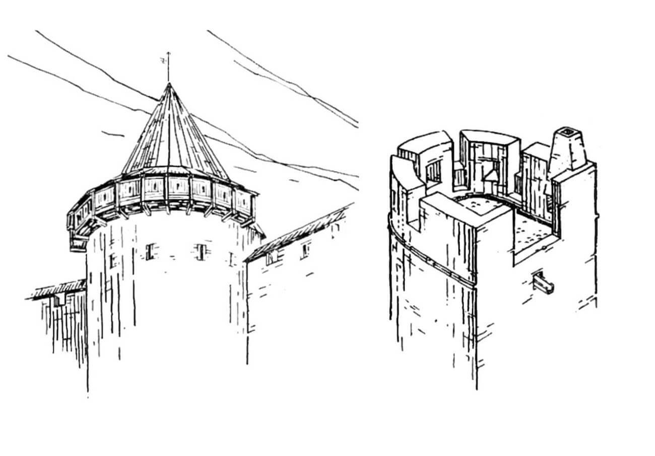
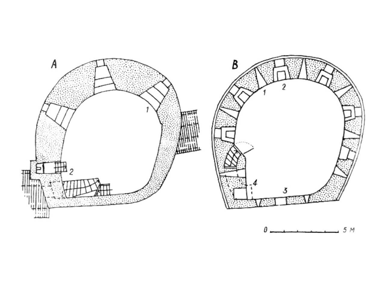
In the mid-14th century, the eastern part of the city was considered relatively safe, protected by curtains, water and earth obstacles. Only the corners, which were crucial for defensive reasons, were reinforced with towers. On the north-eastern side there was a horseshoe-shaped Stolting Tower, and on the south-eastern side there is the Hinko Tower. Work on the expansion of the fortifications in the second half of the 14th century also covered the eastern part of the perimeter, although on a smaller scale than in the areas where the city area was enlarged. Behind the Dominican friary a horseshoe-shaped tower called At the Monks (Munkadetagune) was built, which strengthened the long, over 400-meter section of the wall between the Viru and Sand gates. Originally, it was opened towards the city at the level of the first floor and the upper battle platform, while on the ground floor the rhythm of the pointed arcades of the wall was preserved. The tower At the Monks had a diameter of 8.4 meters and a height of 9 meters from the ground level on the city side. Shortly afterwards, a similar Bremen Tower was built on the northern side of the At the Monks Tower.
At the beginning of the fourth quarter of the 14th century, Tallinn’s city defensive wall already had 24 defensive works in the form of towers, bartizans and gates, with the two western gates still being of wooden construction. Of wood there were also opened battle platforms crowning all the towers and gates, on which throwing machines were placed. Since it were very heavy, along with the stone balls, these platforms had to have a very strong structure, made of two rows of oak logs, then covered with waterproof substances (clay, tar). The towers were probably covered with roofs during peacetime, but due to the flammability of thatch, roofs were removed during periods of danger. On the lower floors, defense was provided by loopholes, on the outside in the form of narrow slits, but on the inside set in recesses and splayed, which allowed for comfortable aiming and a relatively wide field of fire. In some places (e.g. the Golden Leg Tower), slightly wider jambs for the loopholes were used, closed with wooden flaps. The lower defensive floors of the towers served as crew quarters and for storing various types of war materials. At these levels, the walls of the towers were the thickest, from about 1.6 to 1.7 meters, higher up their width decreased slightly.
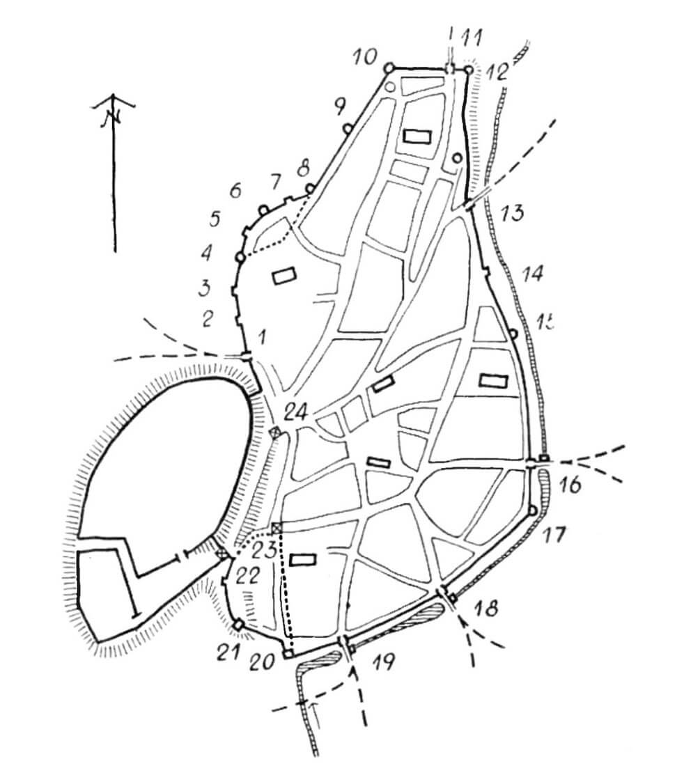
At the beginning of the 15th century, the ring of defensive walls was reinforced with several new towers. On the north-west side, between the Ropemakers’ and Epping towers, the Plate Tower was built, and behind the Epping Tower, the horseshoe Grusbeke Tower was erected, the last one before the corner Rental Tower (Rentenitorn). The short northern section was reinforced with the horseshoe Wulfard’s Tower (Wulfarditagune). As a result, the entire north-western part of the city was protected with densely and relatively evenly spaced towers. In the north-east, between the Stolting Tower and the Sand Gate, two new towers were built: Hattorpe and At the Orthodox Church Tower. To the north of the Viru Gate, the even spacing of towers was completed by the Helleman Tower, and in the south-east by the Devil’s Tower (Duvelitorn). From the south, the city’s defense was supported by the Assauwe Tower. All towers from the turn of the 14th and 15th centuries were built on a horseshoe plan. The construction of the then somewhat archaic quadrilateral towers or bartizan towers was discontinued. Together with the gates, the fortification perimeter consisted of 32 defensive buildings, spaced approximately every 100 meters, except for the north-west section, where the distance between the towers was no more than 50 meters.
In addition to the new towers, older defensive works were also modernized at the beginning of the 15th century. For example, the At the Monks Tower was raised from 9 to 16.6 meters high, the arcades in the rear part of its ground floor were bricked up, and in their place a thin wall was erected, which protruded only 20-35 cm from the inner face of the adjacent defensive wall. The entrance to it was placed at the level of the wall-walk, but there was no separate entrance from the level of the under-wall street. The portal led to the penultimate floor, equipped with four narrow loopholes lined with timber gun rests. On the northern side of the room, a staircase led to a peculiar landing with no loopholes. However, this mezzanine floor was entirely opened to the city, which would indicate the possibility of using it as a warehouse. From the mezzanine, in the opposite wall, another staircase, only 0.6 meters wide, led to the highest floor, which was also opened to the city and was probably originally unroofed. The parapet of the tower was divided by five loopholes, 0.8 meters wide, constituting free spaces between the merlons.
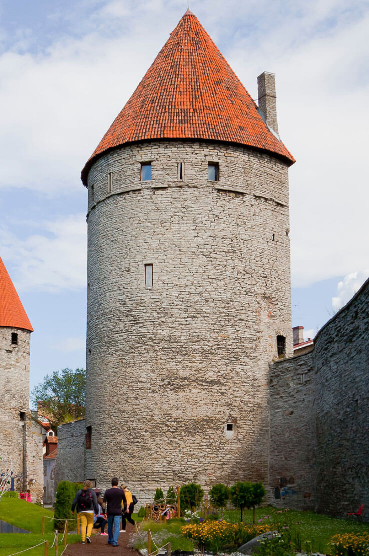
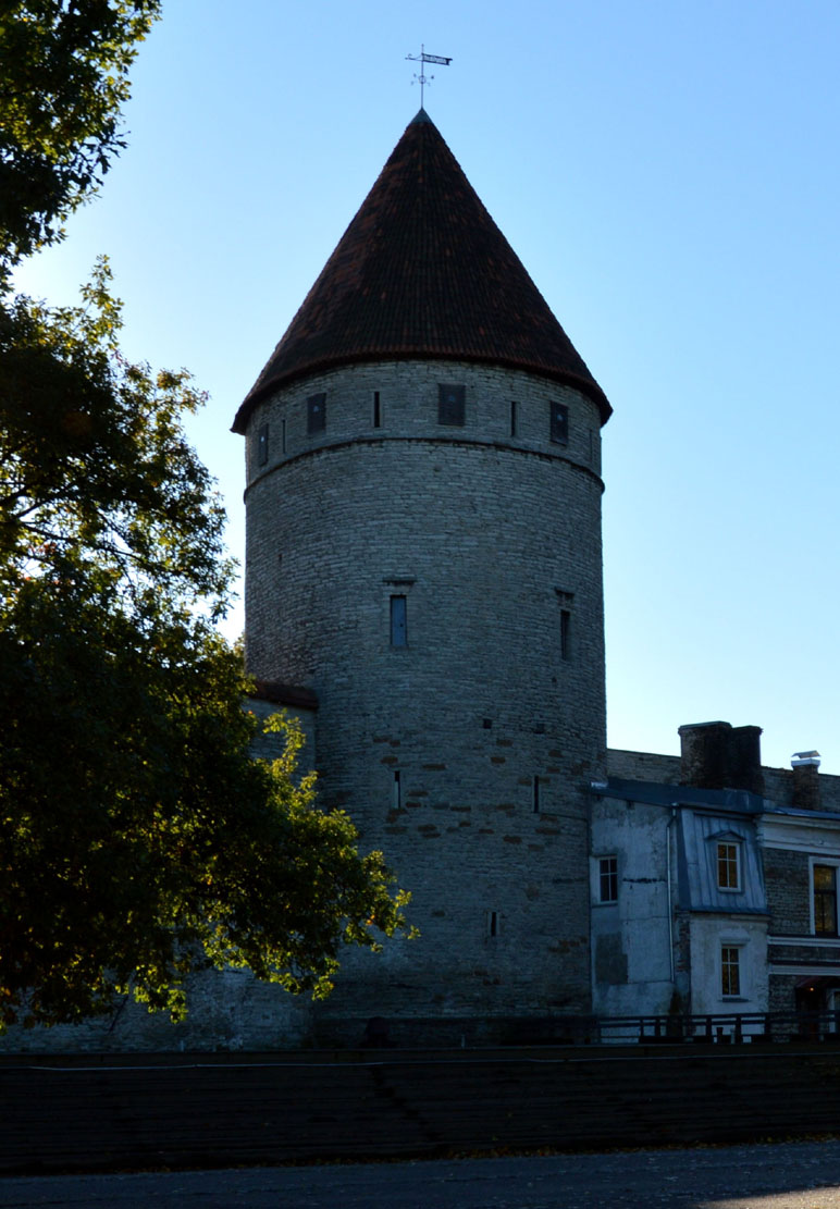
In the mid-15th century, the Bath Tower (Saunatorn) and once again the Golden Leg (Kuldjala) Tower were rebuilt. The latter was thickened on the ground floor from the front to 3.1 meters, and at a height of 13 meters, beams were placed in the openings in its wall to fasten the hoarding porch. Major construction works were carried out on the Nuns’ Tower (Nunnatorn), transformed from a bartizan into a horseshoe tower, a type that gained an advantage in the peak development of Tallinn’s fortifications. The horseshoe towers were mostly protruding in front of the neighboring curtains, had a diameter of about 9.6 meters, a height of 13-15 meters, and their upper floors, like those of the Golden Leg, could be surrounded by hoarding. The interiors were semicircular or round, so the thickness of the walls was not the same. In the central part it was up to 2.9 meters, on the sides it decreased to 2.3 meters, although there were also towers with even thinner walls (for example, after reconstruction the Nuns’ Tower had walls only 1.95 meters thick). As the curtains were raised, the height of the towers increased, with the lower rooms reaching approximately 10 meters in height. Access to them was often only possible through hatches in the ceilings and ladders. In the Helleman and Grusbeke towers, the ground floors had dimensions of approximately 4.7 x 3-4 meters, a height of up to 13 meters and lighting provided by single, high-placed openings. The second floors were much lower, intended for defense, just like the top floors.
In the Bremen Tower, used as a city prison at least since 1435, there was no connection between the lower part and the defensive storey, and what’s more, the high ground floor room was divided into two storeys. Access to them was possible via stairs in the thickness of the defensive wall, ending with a miniature vestibule and a passage at the level of the second floor, where two doors could had bars. The upper cell, about 5 meters high, had iron rings embedded in the walls, used to fasten convicts, as well as a latrine in the southern part of the room. It was illuminated by a single, high-pierced opening with iron grates. The lower cell, 5.7 meters high, was even darker. There was only a latrine with a chute connected to the upper latrine channel and a very narrow ventilation opening under the ceiling. The floor of the cell was made of thick limestone.
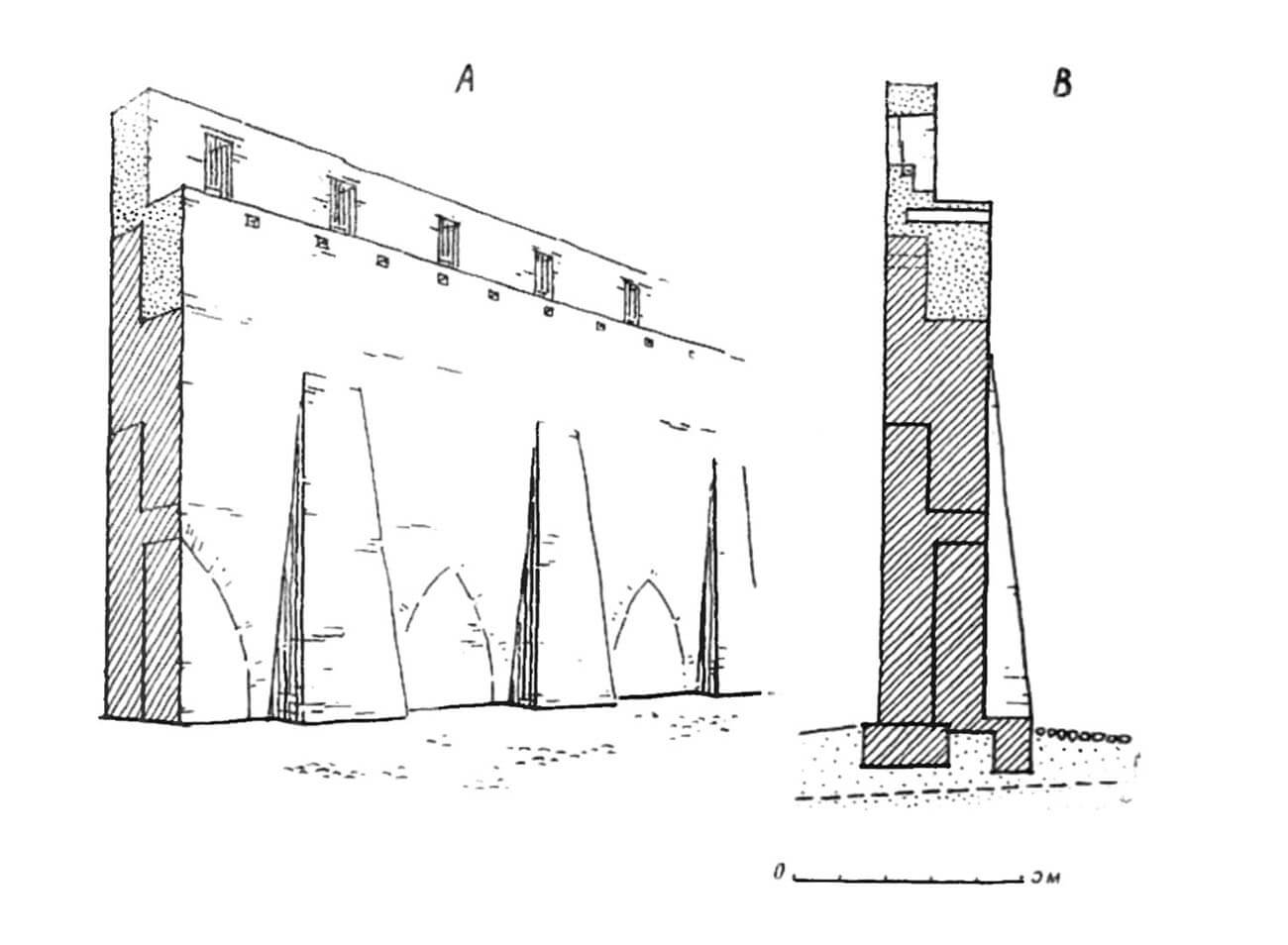
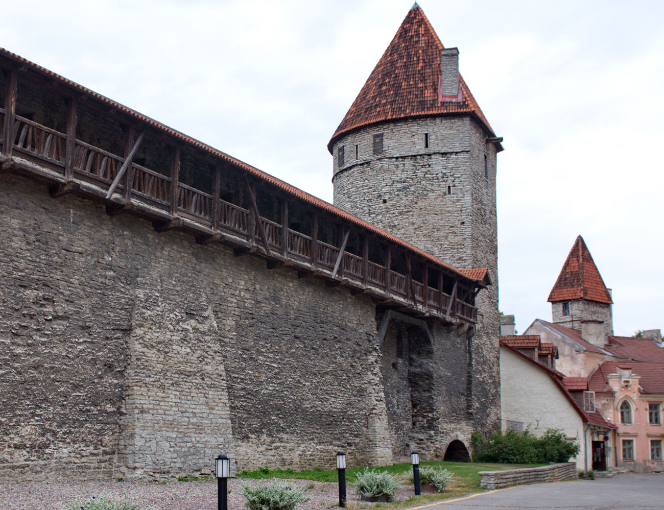
In the first half of the 15th century, the city wall with pointed arcades turned out to be too weak against the rapidly developing siege art and firearms. The curtains were significantly raised, which, combined with the unstable ground and weak foundations, forced the addition of buttresses on the street side and the bricking up of the arcades between them. The foundations of the buttresses were set in an artificial embankment, which was then hardened by paving of the streets under the walls. On the section between the Viru Gate and the Hinko Tower, buttresses were also added on the outside of the wall (as well as on the Hinko Tower itself). This was probably related to the very weak ground and the mill pond, which almost reached the walls. By contrast, in some places there was no need to build buttresses at all. The raised curtains on most of the perimeter reached 11 meters high to the level of the wall-walk. On the outside they were raised by another 2.2 meters of the battlemented breastwork. The loopholes in the new battlement were slightly smaller than before. The width of the wall-walk was about 1.4 meters, but in some places, e.g. at the Helleman Tower, it was widened by beams embedded deep in the floor, on which a wooden porch was placed.
Before the mid-15th century and in some cases already in the 14th century, modernization works on the city gates began. It was decided than to strengthen them with foregates extending towards the moat. Foregates were built more or less in the same form. All were straight, elongated necks, the side and front walls of which were equipped with wall-walks and loopholes. The foregates were connected to the gate towers, which had portcullises and strong doors. The foregates also had doors, additionally equipped with drawbridges over the moat. At several gates (Viru, Cattle, Harju, Coastal), presumably in the second stage of work, the foregates were equipped on the sides of the necks with small towers flanking the entrance portal, built on a circular plan, but with four-sided plinths. At some of the foregates, 14th-century mills were still operating, located over the moat near the side walls. Because it were located at important points for defense and their doors opened onto the foregates, the mill buildings also had to be part of the gate defense.
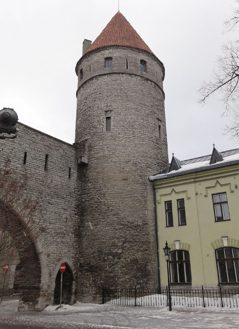
Until the mid-15th century, the only stone gate on the western section of the fortifications was Long Leg (Pika Jala). Only then was the Short Leg Gate (Lühikese Jala) rebuilt using stone, and in the years 1454-1455 both gates were connected with a stone wall running parallel to the eastern slope of the castle hill. The section between the Long Leg Gate and the Bath Tower was also completed with a wall, as previously only wood and earth fortifications existed. Within the length of this curtain, before 1458, a five-story tower was built on a three-quarters circular plan, 6.8 meters in diameter and 16.5 meters high, traditionally called Under the Hill (Seegitagune). Moreover, in the western section another tower was built in the second half of the 15th century, called Behind the Bath (Saunatagune). It gained slightly larger dimensions: a diameter of 9.8 meters and a height of 19 meters, although it had the same number of floors. Both Long and Short Leg gates had the form of four-sided towers with passages on the ground floor.
The second, outer strip of the defensive wall, forming a zwinger, was built only on the south-west and north-eastern sides of the city, which was probably related to the original topography and the proximity of the moat to the main defensive perimeter. In the south-west, the hilly terrain with the development of firearms turned out to be dangerous for defenders, so a second wall was built from the Goat Tower to the castle wall on the western side of the Short Leg Gate. The north-eastern zwinger at the foot of a large slope protected the area from the foregate of the Sand Gate to the Stolting Tower. From the outside, it was reinforced with buttresses.
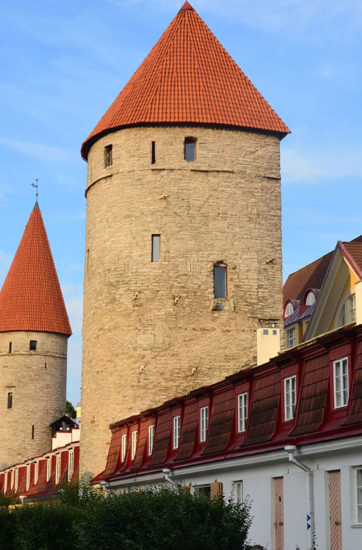
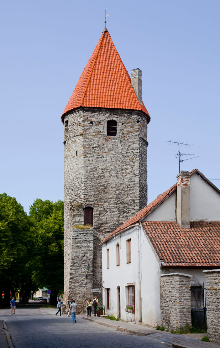
In the second half of the 15th century, the curtains of the defensive wall and towers were raised for the last time. The latter eventually reached an exceptionally high height of about 20-24 meters. The reconstruction, based on a new plan that was supposed to harmonize the appearance of the defensive works, included at least 13 towers: Bath, Behind the Nuns’, Lippe, Nuns’, Loewenschede, Plate, Grusbeke, Stolting, Hattorpe, Bremen, At the Monks, Helleman and Assauwe. In each of them, two new upper floors adapted to the use of firearms were created. The form of many loopholes was changed, now facing the foreground with wider rectangular jambs made of ashlar. Inside grooves were drilled in the side walls of the loopholes, in which horizontal beams were placed, serving as bases for weapons. The openings could also be closed from the inside with flaps. In some towers (e.g. the Nuns’ Tower), latrines were created on the sides, supported by stone consoles. Inside, the new floors were separated by wooden ceilings, for safety reasons connected only by ladders (it could be easily pulled up in the event of a danger). In order to alleviate the hardships of the guard service, fireplaces were also built in the towers, most often located on the penultimate floors. Other amenities included openings on the city side on the highest floors of the towers, through which weapons and supplies could be bring to the top.
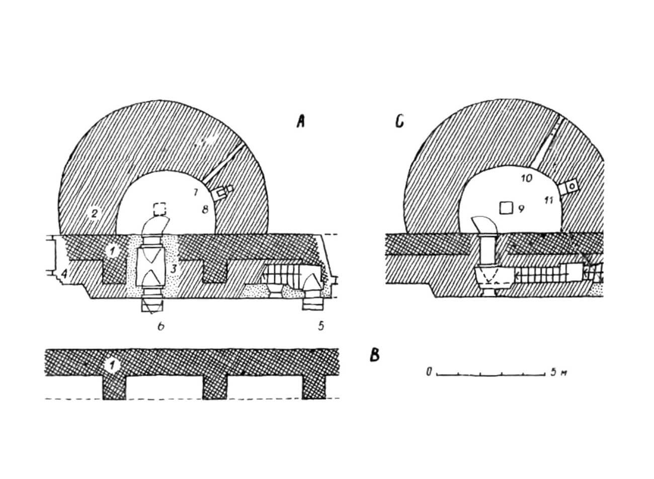
As in the 14th century, late medieval towers were roofed only in times of peace, while in times of danger the roofs were dismantled, leaving open platforms protected by battlements. For this purpose, the floors at the top had to be waterproof and covered with paving stones laid on a layer of clay. The floor usually consisted of two inclined planes that intersected on the axis of symmetry of the tower, creating a gutter that was also slightly inclined to drain rainwater into a gargoyle at the rear wall of the tower. The heavy floors of the towers required solid foundations, so barrel vaults were often built under them, although wooden supporting structures were also used in smaller towers. All Tallinn towers from the second half of the 15th century were made at a high level of construction technology, characterized, among other things, by the precise processing of limestone stones. At the end of the construction works, the external facades of the towers were covered with a thin layer of plaster, thanks to which the fortifications had to be very bright.
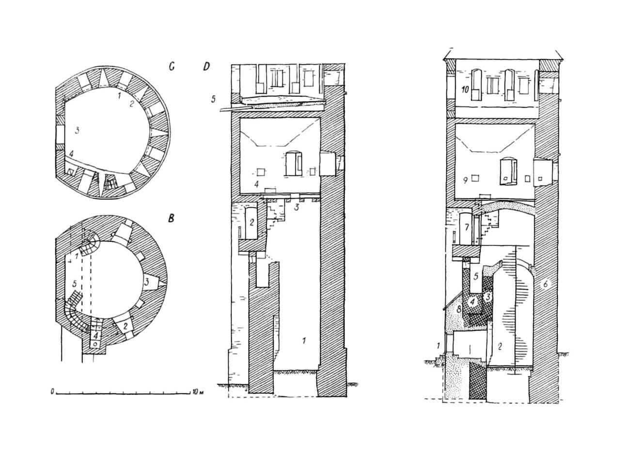
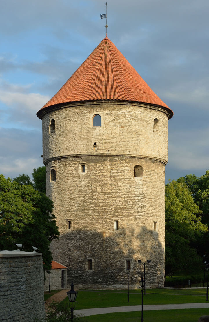
At the beginning of the fourth quarter of the 15th century, a new tower called Kiek in de Kök was built, located in the corner of the southwestern wall of the zwinger. Initially it was low, on a three-quarter circle plan, but at the end of the 15th century it was thoroughly rebuilt into a massive, cylindrical cannon tower with a considerable height of about 35 meters, which justified its name (Look into the Kitchen), referring to the possibility of viewing nearby houses from the top floor. The older structure was left as the core, while a coat of cylindrical wall was added from the outside, thanks to which the diameter of the tower was as much as 17.3 meters. The wall was 4.5 meters thick on the ground floor and about 3.7-3.9 meters in the upper parts. The tower’s cylinder was topped with a projecting upper part, approximately 4.5 meters high, supported on a three-step cornice. Inside, there were six floors connected by a spiral staircase, the first five of which were covered with vaults. The ground floor, lit only by one opening on the south side, served as a gunpowder warehouse. Above, there were four defensive floors with loopholes for guns, equipped with fireplaces for the crew. The top floor had 11 loopholes in a 1.3-1.6 meter thick breastwork and a cobbled, sealed floor with grooves for water drainage, indicating the open nature of this floor, at least for the duration of hostilities. In the rear part of the tower (facing the city) there were staircases, chimneys and rooms in the thickness of the walls, intended for the use of the crew and transport. The latter took place inside the tower using holes left in the vaults and a system of ropes with turnstiles that connected all floors with the warehouse ground floor. External transport was also possible on the city side of the building, similar to that in other towers.
At the turn of the 15th and 16th centuries, due to the final replacement of baroballistic machines by firearms, the towers received permanent roofs. New, larger loopholes were introduced in the breastworks of the highest floors, due to the roofs topped with lintels. Their protection was provided by wooden flaps hanging from the outside. The transport openings for pulling in guns and ammunition have also been enlarged. For the same reasons, access to the lower floors was also significantly expanded. These changes were probably applied at the earliest on the north-western section, in the Epping, Golden Leg and Ropemakers’ towers.
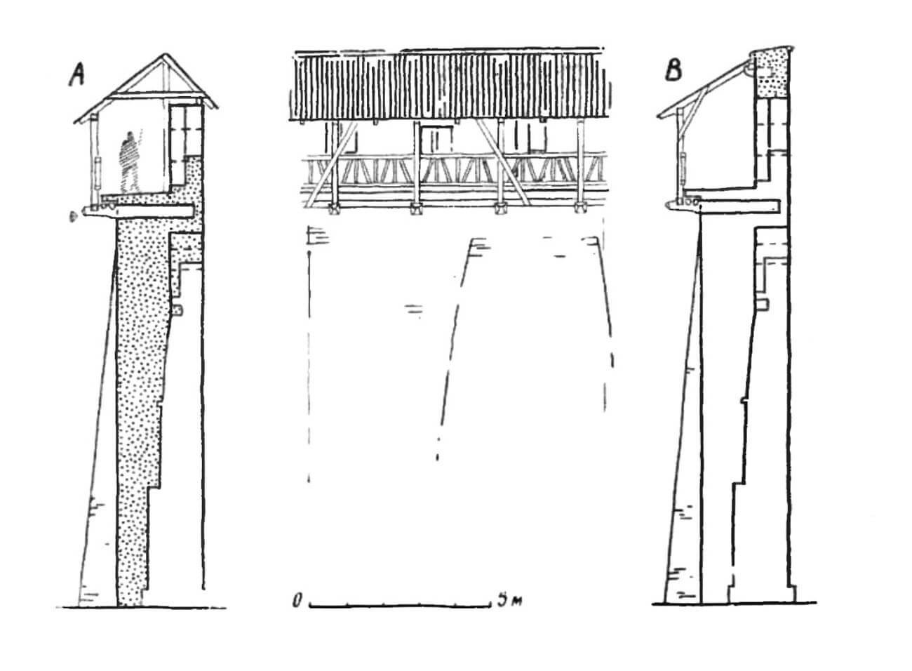
In the first half of the 16th century, the curtains of the walls were raised along with the towers, although probably not in all sections. On the eastern side of the perimeter, the wall was raised by 3 meters, which made the total height of the city wall 14 meters, plus an additional 2.6 meters of the breastwork. In places, the breastwork was even higher, so the height of the entire wall was over 16 meters (the curtain reached such dimensions at Helleman Tower, which was probably the highest in the entire city). After raising the height of the walls, the wall-walks was re-established, widened with roofed wooden porches, first mounted on wooden beams, then on stone consoles. In several of the battlement embrasures there were crossbeams to support small fire arms.
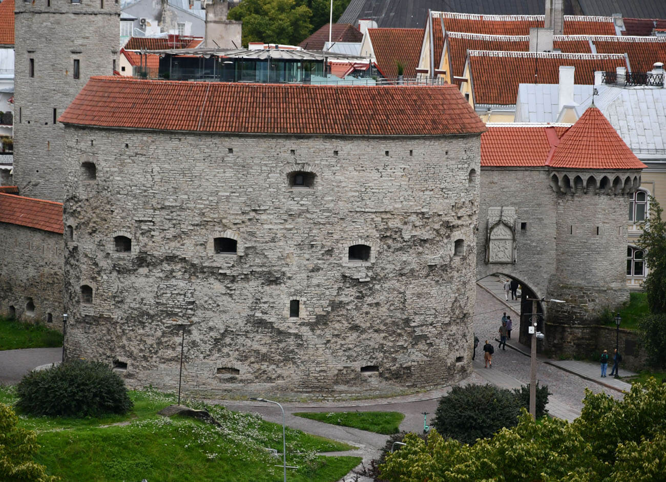
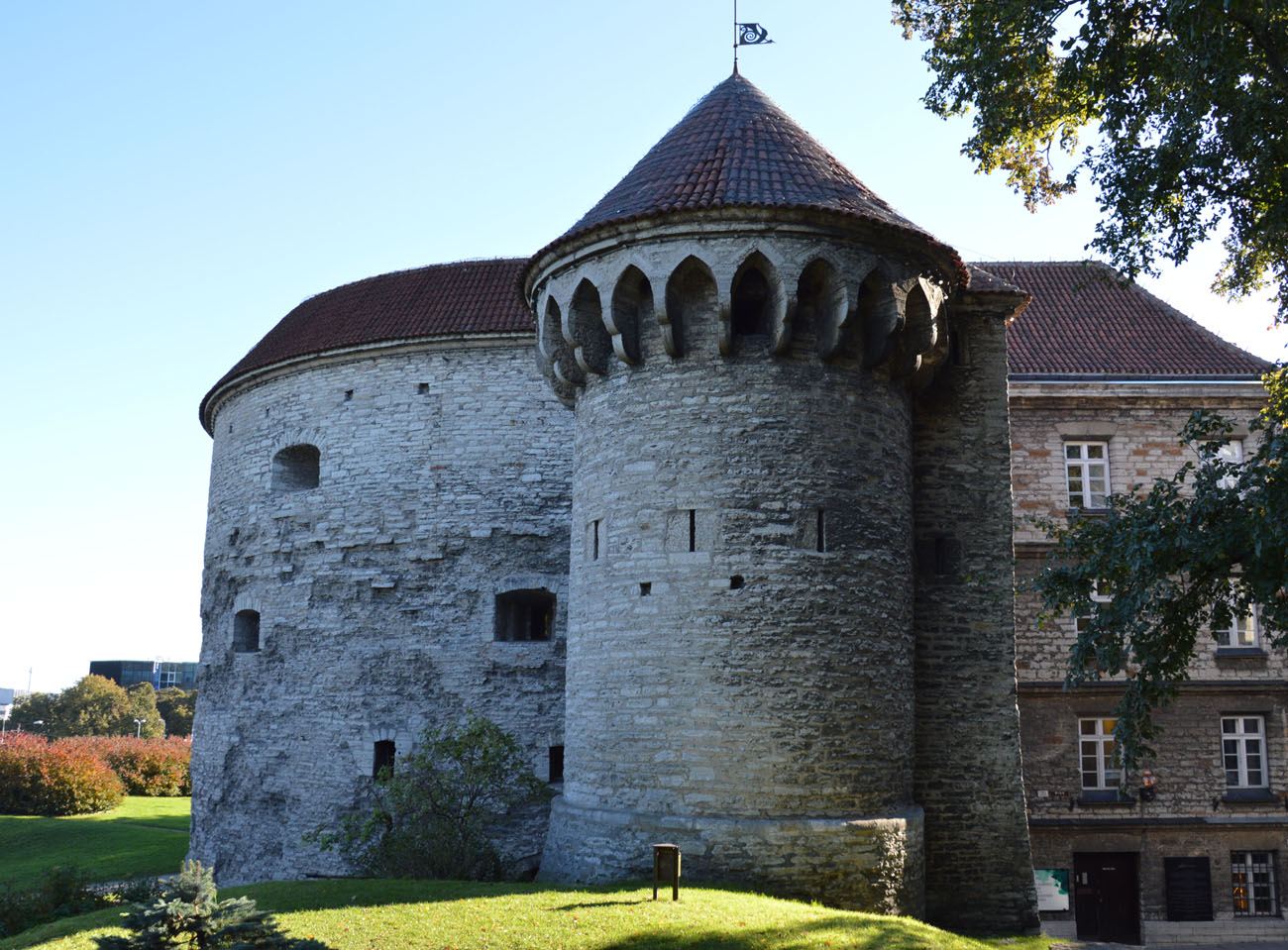
In 1510, in front of the Coastal Gate, on a sandstone rock raised approximately 5-8 meters above the level of the port, the construction of the massive Fat Margaret Bastion (Paks Margareeta) began, originally called Rosencrantz. It was planned to be as much as 24 meters in diameter, so in order to build it, part of the old foregate was demolished, including the upper part of the western tower flanking the passage, on which a new structure topped with machicolation was built. The eastern tower was replaced with a bastion, and the gate passage itself was widened, equipped with door and a portcullis. The device for lifting the portcullis was located in the building above the passage, which connected the bastion with the western tower and the wall-walks guarding the side walls of the foregate. The bastion was originally topped with machicolations. Its intended for heavy guns loopholes was not strongly splayed, but there were openings for the discharge of gunpowder smoke and side holes for weapon rests. Moreover, in the straight rear wall of the bastion there were openings for transporting war materials. The bastion was probably roofed, but due to its large size, the roof was supported on a central pole.
In the 1530s, in front of the Cattle Gate a bastion called Luerborch was built, slightly smaller than Fat Margaret, but on a similar horseshoe shape. Its diameter was about 20.4 meters and its height was around 18 meters. It had three floors with loopholes for guns. Nearby, in the southern and southwestern outskirts of the city, earthworks were also carried out on the ramparts, heralding a new era in the history of fortification art. Prominent in their line was the earthen bastion in front of the Kiek in de Kök Tower, intended to protect its lower part.
Current state
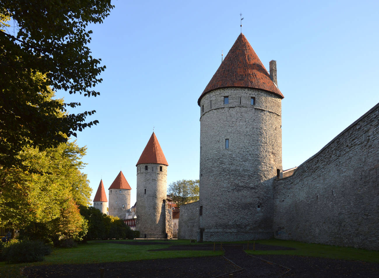
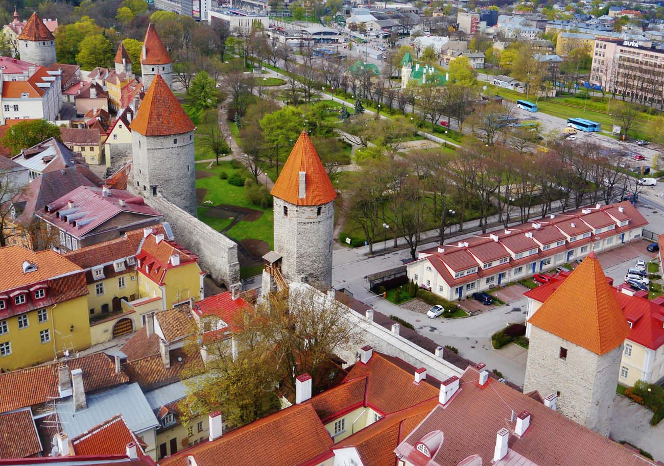
Nowadays, Tallinn is one of the few cities with a well-preserved system of medieval fortifications. To this day, 26 towers and about 1.85 km of the defensive wall have survived. Although many of the towers and sections of the wall have survived in full height, it is worth remembering that due to the raising of the ground level over the centuries, they are lower by an average of 2-4 meters compared to the state at the end of the 15th century. Moreover, in many towers in the early modern period, the loopholes, entrances, transport openings, and internal divisions were transformed, and the crown of the walls has often not preserved (due to the repeated raising of the curtains in the Middle Ages, fragments of the oldest parts of the walls are visible on the facades). A great loss is the complete destruction of most of the city’s gate complexes, especially in the southern section.
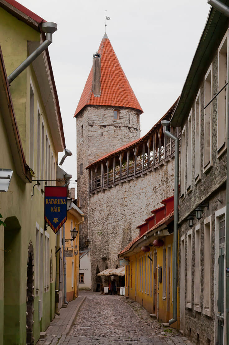
Currently, the western and north-western fragments of the former circuit are best presented, starting from the towers of Grusbeke, Epping, Plate, Ropemakers’ (Köismäe), Loewenschede, Behind the Nuns’ (Nunnadetagune), Golden Leg (Kuldjala), Bath (Saunatorn), At the Nuns’ (Nunnatorn), while the upper part of the Bath Tower is today the result of reconstruction using the Nuns’ Tower as a model. Fortunately, the foreground on a large part of this section of the fortifications was not blocked by buildings. Further on, near the castle hill, two gates have survived: Short Leg (with the upper part rebuilt) and Long Leg, as well as a large south-western fragment, where the Stable (Tallitorn) Tower stands out, the Virgin’s Tower (Neitsitorn) and the Kiek in de Kök cannon tower from the end of the 15th century, unfortunately significantly transformed in the 17th and 18th centuries (now it houses a branch of the Tallinn City Museum).
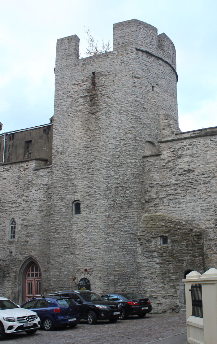
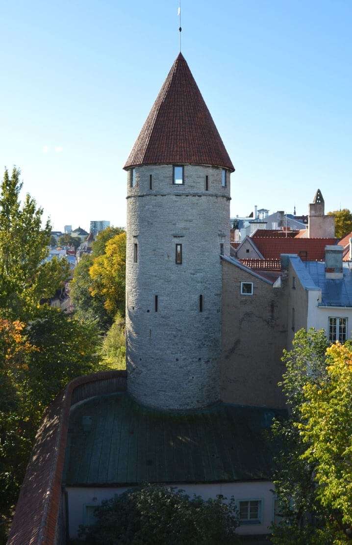
On the southern and eastern sides of the original ring of fortifications, many elements of medieval fortifications have also been preserved, although more often they are single towers, hidden in the modern urban buildings, e.g. Assauwe Tower, At the Monks Tower (Munkadetagune), or Helleman Tower. To the north you can see the Stolting Tower and the Bremen Tower, reconstructed to the form of a typical Tallinn tower from the second half of the 15th century. It is also worth mentioning the Viru Gate, specifically two towers which are preserved fragments of the foregate. On the northern edge of the fortifications, the foregate of the Coastal Gate (Suur Rannavarav) has been preserved, including the Fat Margaret Bastion (Paks Margareeta) from the early 16th century. Unfortunately, it no longer has the original crown of walls and machicolations. Currently, it houses the Estonian Maritime Museum.


bibliography:
Bernotas R., New aspects of the genesis of the medieval town walls in the Northern Baltic Sea region, Turku 2017.
Borowski T, Miasta, zamki i klasztory, Inflanty, Warszawa 2010.
Kadakas V., Nurk R., Püüa G., Talvar P., Toos G., Investigation of the medieval and early post-medieval Karja gate and the suburb in front of it in Tallinn, „Archeological fieldwork in Estonia 2010”, Tallinn 2011.
Kadakas V., Reppo M., Excavations at the Great Coastal Gate of Tallinn, „Archeological fieldwork in Estonia 2019”, Tallinn 2020.
Russow E., Die Hansestadt Tallinn (Reval) und ihre mittelalterlichen Befestigungen, “Lübecker Kolloquium zur Stadtarchäologie im Hanseraum. Die Befestigungen”, 7/2010.
Zobel R., Tallinna linnamüür, Tallinn 1966.