

History
The castle was built in the early 12th century as part of the securing and settling of the surrounding lands after the Anglo-Norman invasion of Dyfed in 1093. It was founded by Wizo the Fleming, a Flemish mercenary, whose name gave the new seat its name. The Wizo family was probably part of the entourage of William the Conqueror’s Flemish wife, Queen Matilda. During the reign of Henry I, many such newcomers were a burden on the royal court, while fights raged in south-west Wales, giving them the chance to gain fame and fortune. Wizo found himself in lands that had been conquered by Arnulf de Montgomery, Earl of Shrewsbury. The Earl established his seat at Pembroke, and then expanded and secured the territory by building more castles or allowing his liegemen to do so. The castle initially known as “Castellum Wiz” was one of these strongholds. It was located within the Welsh cantref of Daugleddau, which was incorporated into the Landsker Line, the boundary of 12th-century Anglo-Norman rule, separating the native Welsh from the Anglo-Norman and Flemish colonists.
In the 12th and early 13th centuries, Wiston was at the forefront of the fights between the Anglo-Normans and the Welsh. In 1147 it was captured by the Welsh under Hywel ab Owain, which was the first direct mention of the castle in records. It was probably recaptured shortly afterwards by Wizo’s son, Philip de Gwys, who had already adopted the Welsh form of the castle’s name. In 1193, Wiston was devastated by Hywel Sais’s raid. He managed to capture the lord and his family, but held the castle for only two years, until it was recaptured on Whit Sunday 1195. Another attack was carried out in 1220, this time by Llywelyn ap Iorwerth. The castle and the neighbouring borough were then burned, but the Welsh withdrew without attempting to hold on to their gains. On the orders of King Henry III, the castle was rebuilt by William Marshal, Earl of Pembroke, who probably initiated the replacement of the wooden fortifications with stone ones.
In the second quarter of the 13th century, Wiston Castle probably lost its importance. It was mentioned sporadically in records after 1231, as was the borough outside the castle, which had been in decline since the mid-14th century. Presumably in the 14th or 15th century, the castle was abandoned in favour of a more comfortable manor house, the ownership of which passed from Wizo’s descendants to the Wogan family at the turn of the 13th and 14th centuries. It is likely that the late medieval manor was already referred to in the information from 1419, about monthly court sessions in Wiston. The castle was certainly in existence in some form by the time of the 17th century Civil War, for the abandoned fortifications were occupied by Royalist forces in 1643. The defeat of the royal forces at the Battle of Colby Moor in 1644 caused the garrison to withdraw from Wiston.
Architecture
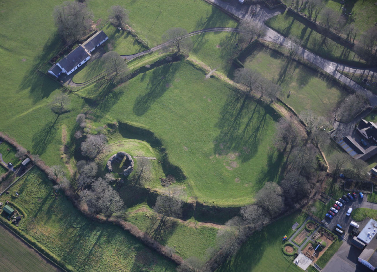
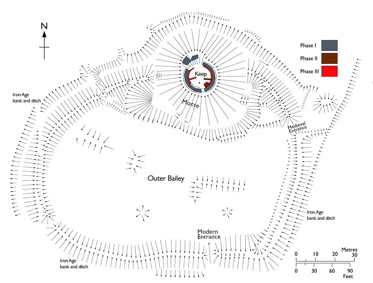
The castle was founded on a hilly terrain, devoid of any large natural mountains. In the Middle Ages, the lower areas could have been marshy and boggy, as the entire region was crossed with numerous small streams, which the first colonists regulated with dykes and dams. Initially, the castle was built of earth and wood, and during the construction of the exceptionally large outer bailey, the ramparts that had existed since the Iron Age were probably also used. The main element of the castle was a 9-12-meter-high earth mound in the form of a truncated cone (motte), on which a timber tower could have been built, surrounded along the edges of the slopes by a palisade. A ditch with a minimum depth of 2-3 meters surrounded the base of the mound, separating it from the outer bailey to the south and connecting with the moat of the outer bailey on the eastern and western sides.
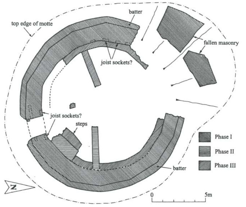
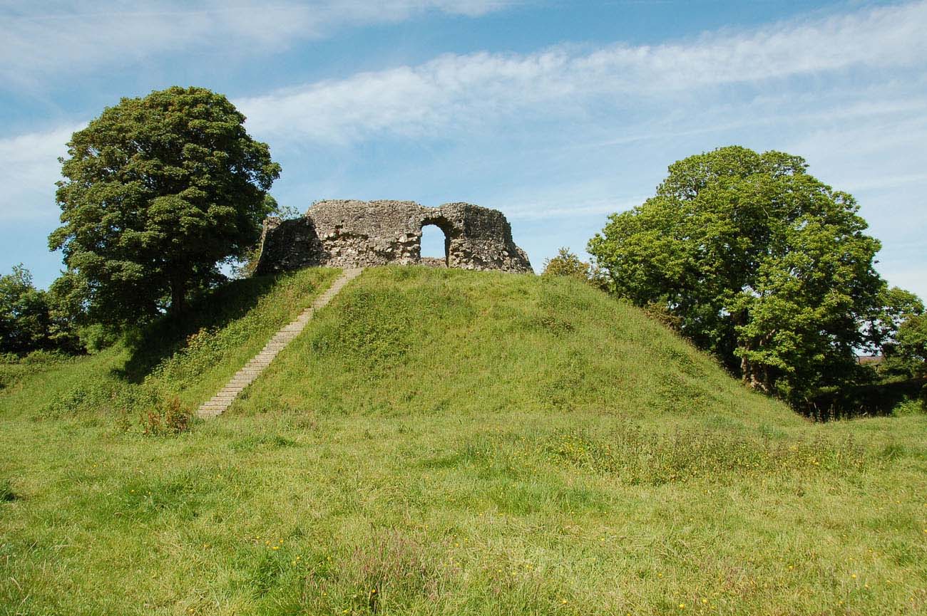
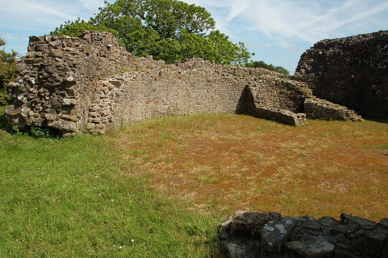
At the turn of the first and second quarter of the 13th century, the timber fortifications of the motte were rebuilt into a stone wall in the shape of a sixteen-sided shell keep with a maximum height of about 4 meters. Its thickness was about 1.4 meters above the batter, which due to the sloping external elevations on the ground floor was about 2 meters thick. The wall closed the inner courtyard with a maximum diameter of about 12 meters, with a semicircular gate portal on the southern side. The internal development initially remained wooden, but as a result of the expansion, on the eastern side a transverse stone wall was built, and stone steps were created between it and the entrance, indicating the building of an additional structure above the gate. There was certainly also access to the walk in the crown of the walls, which must have been topped with a parapet and battlements. In the next phase of expansion, the wall on the entire inner elevation was reinforced by increasing the thickness by an additional 0.6 meters, which reduced the internal diameter of the shell keep to 10.7 meters. At that time, a second transverse wall was also built, which together with the older one left a passage a few meters wide in the middle of the keep. The walls could have served to divide the courtyard into the entrance and rear parts, and could also have been an element of the residential buildings.
The castle outer bailey developed on the southern side of the motte, where wooden and earth fortifications surrounded a flat, oval area measuring approximately 125 x 80 meters. This very extensive area was filled with residential and economic buildings, probably entirely of wooden or half-timbered construction. Entry to the bailey was from the east. The gate was placed relatively close to the motte, so that it could be within the range of the guards and so that those heading to the main part of the castle would face it on the right, i.e. with side without a shield. Perhaps a smaller guardhouse was also located on the bailey at the base of the motte, in front the stairs leading to the keep. The borough on the southern and eastern sides of the castle had no ramparts. It was divided into a regular system of plots, separated by a road running latitudinally, widening in the middle to form a market square, near which there was a church.
Current state
Wiston is considered one of the best preserved motte and bailey buildings in Wales. The earth mound, the surrounding moat and earthworks of the castle, are all in very good condition, especially visible on the north and north-west sides, where the rampart still rises to a height of 3 metres and the ditch is at least 2.5 metres deep. On the top of the mound are visible stone relics of the 13th century fortifications. Thirteen sides of the former shell keep survive, while three or four on the north side have collapsed down the slope of the mound. From the highest point of the castle there is a panorama with views south across the lowlands of southern Pembrokeshire and north across the rolling countryside towards the Preseli Mountains. The castle is maintained by Cadw and is open all year round free of charge.
bibliography:
Kenyon J., The medieval castles of Wales, Cardiff 2010.
Murphy K., The Castle and Borough of Wiston, Pembrokeshire, „Archaeologia Cambrensis”, 144/1997.
Salter M., The castles of South-West Wales, Malvern 1996.