
History
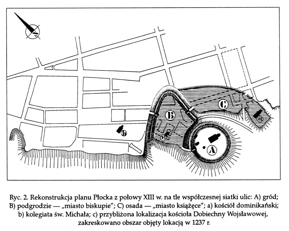
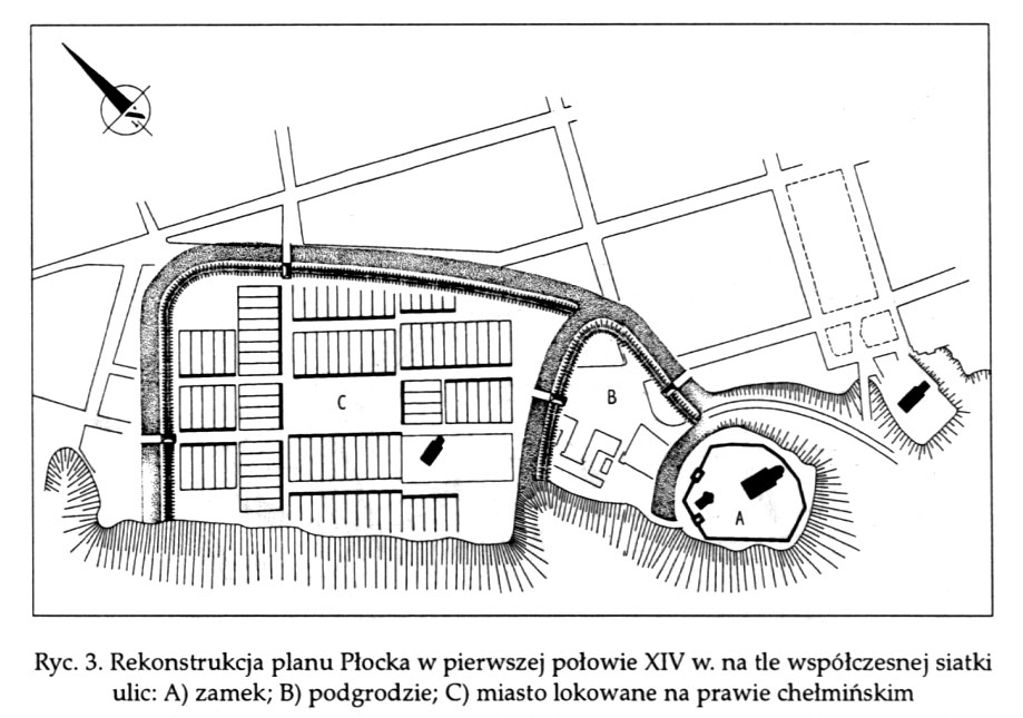
Already before the mid-13th century, Płock had wooden and earth fortifications, but it probably only surrounded the Old Town. It is not known whether this system was extended to the whole town after its integration. In any case, these early fortifications were ineffective, because in the 13th and the first half of the 14th century, the town was destroyed several times, and chronicler Jan Długosz justified the decision to build defensive walls with the necessity of securing Płock against Lithuanian attacks. The construction of the town walls begun in 1353. It surrounded the entire town, also from the side of the Vistula river. The total construction cost can be calculated at 8000 grzywna (weigt units), and because it is known that there was a total of 500 grzywna per year for this purpose, the work should have been last fot 16 years. Although the town was organized for a long time and certainly not well-founded, the king covered 80% of the needed sums, and the townspeople only 20%. The decision of king Casimir the Great regarding the Płock fortifications was consistent with the general direction of his defense activities. But this undertaking also had a special meaning, for it meant strengthening the city that was freshly incorporated into the kingdom.
Nothing is known about modernization works at the walls. Perhaps later, moats and earth ramparts were made and the Dobrzyń Gate was extended. In 1532, there was a disastrous slump of the Vistula escarpment, as a result of which the part of the castle and a considerable section of the defensive wall collapsed. It was not rebuilt. Płock suffered serious damages along with his fortifications during the Swedish wars, from which the fall of the fortifications dates. In the 18th century, liquidation of the underwall street, overbuilding of walls and adaptation of towers took place in many parts of the city. Occasional demolition of fortifications began at the end of the 18th century, and in 1803, the Prussian authorities issued a decree on total demolition.
Architecture
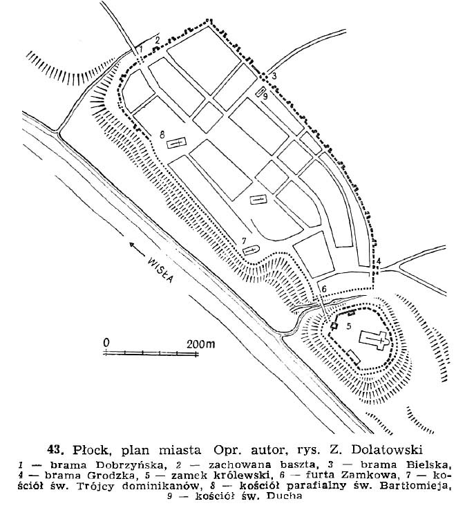
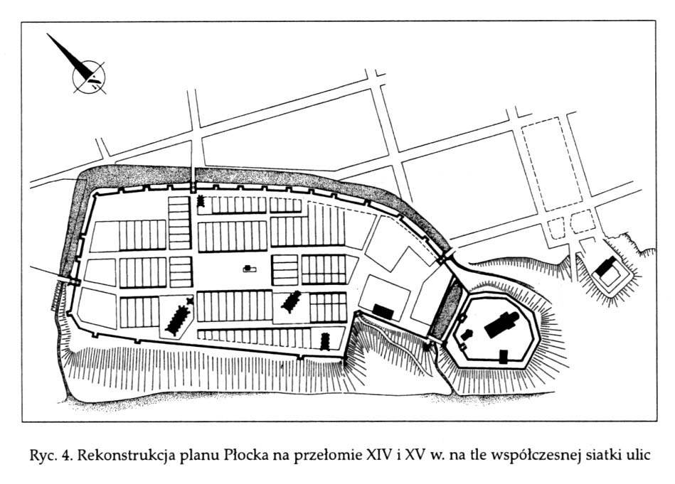
Płock had an elongated shape along the Vistula slope. The western corner of the town was rounded, and in the south-eastern part the city narrowed on both sides. The area of the town within the walls was over 18 ha, the length of the fortification line was about 1800 meters. The town walls were surrounded by a underwall street. The south-west section of this street was formed by Nadwiślańska street, which in 1532 disappeared together with the walls, as a result of slipping down the slope.
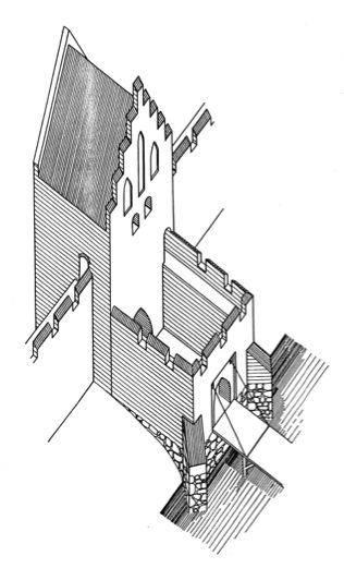
The defensive wall was made of brick, tied in a flemish bond and set on a stone foundation. The thickness of the aboveground part of the wall was about 1,70 meters, the height according to the contract should be 9,3 meters above the foundation. The culmination of wall is not known. The fortifications were provided with towers located around the perimeter and based on iconographic sources, 19 of them can be located from the north-east, north-west and partly from the Vistula. Originally, there were several more of them, as it is known that the towers also appeared in the further part of the south-eastern side of the town. On known sections, the spacing of towers was 35-65 meters, so it was only in a few cases consistent with the recommendations of the document from 1353. All towers were the same: rectangular in plan, occurring in front of the defensive wall and open to the interior of the town. Had dimensions of 8,2 X 5,5 m and protruded outside the defensive wall at 3,8 meters. The height of the towers is unknown, but the thickness of their wall was about 2-2,15 meters. In the fifteenth century, at least part of them was closed with a wall from the city side.
The town had three gates: Castle Gate, also called Wyszogród Gate from the east, Bielska from the north-east and Dobrzyń from the north-west. The Bielska and Grodzka gates were located in single, rectangular gatehouses, the first of which was set on the axis of the defensive wall, and Grodzka occurred in front of the defensive wall. Doubts are about the shape of the Dobrzyń Gate. As the only one in Płock, it was two-part, so it probably consisted of a gate tower and foregate, perhaps later added. The inner part of the gate, in a manner not found in other Polish towns at that time, was completely extended inside the city. Thanks to archaeological research, the dimensions of the tower of the Bielska Gate are known, they were 8 x 8.55 meters in the plan, and the foregate (added at the beginning of the 15th century) was 8.45 meters long and had the width equal to the gate tower. Access to the gate was provided by a wooden bridge over the moat. Apart from the above-mentioned gates, in the area of the southern corner of the town, there was a castle wicket gate constituting the entrance to the castle through the bridge over the moat and probably the second wicket gate serving as a descent to the Vistula.
From the north-west and north-east, this is all over the area where fortifications ran along flat terrain, the defensive walls were reinforced from the outside by a moat with water and a earth ramparts. These could be primal elements or later formed as a result of expansion of the fortification belt. This second hypothesis seems more probable, because in the contract from 1353 there is no mention of a moat. Archaeological research has found that the moat was on various sections from 20 to 35 meters wide and had obliquely formed banks. Their inner slope was formed by a clay bench reaching the wall. A covered road ran along the counterslope, covered with planks and secured with a palisade. The depth of the moat was about 4 meters.
Current state
A fragment of a 15 meters long and a 5 meters height wall was preserved in the north-eastern part of the district, next to the former Bielska Gate. The second element of fortification is the tower at Okrzeia street. It is today part of the house. Other fragments of the defensive wall, currently invisible, are probably located in the walls of buildings, first of all the odd side of Kwiatka street.
bibliography:
Płock wczesnośredniowieczny, red. A. Gołembnik, Warszawa 2011.
Widawski J., Miejskie mury obronne w państwie polskim do początku XV wieku, Warszawa 1973.